You are here

Visualization

Global Drought Monitor

An working example of the Global Drought Monitor, focusing on Eurasia and Africa.

Image: An working example of the Global Drought Monitor, focusing on Eurasia and Africa.

drought.mssl.ucl.ac.uk - Benjamin Lloyd-Hughes and Mark Saunders

The Global Drought Monitor  is a free internet application which monitors the severity of drought worldwide on an ongoing basis. The product will aid humanitarian relief by assisting warnings of potential food, water and health problems. The Global Drought Monitor  will also benefit the general public, government and industry by improving awareness of droughts and their impacts.

(VIEW WEBSITE)

Country / Region Tags: 
Problem, Solution, SitRep, or ?: 

Searching social media sources by geography

submitted by Samuel Bendett

homelandsecuritynewswire.com - November 16th, 2012

Geofeedia has created a group of algorithms that can search multiple social media sources by geography in real time.

“You just type in a place name, address and zip code (to find a Tweet, video or image),” CEO Phil Harris told the Chicago Sun Times.

Harris started and financed the company with chief operating officer Mike Mulroy and chief technology officer Scott Mitchell.

(VIEW COMPLETE ARTICLE)

Country / Region Tags: 
Problem, Solution, SitRep, or ?: 

Probability Maps Help Detect Food Contamination

Sandia's stochastic network metholodogy accelerates spread of food-borne illness // Source: sandia.gov

submitted by Luis Kun

Homeland Security News Wire - October 1, 2012

Researchers demonstrate how developing a probability map of the food supply network using stochastic network representation might shorten the time it takes to track down contaminated food sources; stochastic mapping shows what is known about how product flows through the distribution supply chain and provides a means to express all the uncertainties in potential supplier-customer relationships that persist due to incomplete information

Uncovering the sources of fresh food contamination could become faster and easier thanks to analysis done at Sandia National Laboratories’ National Infrastructure Simulation and Analysis Center (NISAC).

Country / Region Tags: 
General Topic Tags: 
Problem, Solution, SitRep, or ?: 

Protests spread against US over anti-Islamic film - as it happened

A Google map locating protests around the world tied to a low-budget video produced in canyon country north of Los Angeles. Photograph: Google

Image: A Google map locating protests around the world tied to a low-budget video produced in canyon country north of Los Angeles. Photograph: Google

guardian.co.uk - September 14th, 2012 - Matthew Weaver, Brian Whitaker and Tom McCarthy   

Protest activity smoldered in Cairo, Tunisia, Lebanon and elsewhere after a day of upheaval in the Middle East and North Africa. Relatively small but intense protests outside US embassies across the region resulted in multiple fatalities in Tunis and at least one each in Lebanon and Cairo.

Gunmen staged a raid on a peacekeepers' outpost in Sinai, with three foreign soldiers, believed to be Colombian, reportedly injured. The raid was described as major, with dozens of fighters and vehicles, and was not of a kind with the protests outside US diplomatic outposts.

(VIEW COMPLETE ARTICLE)

Country / Region Tags: 
Problem, Solution, SitRep, or ?: 

This Is Now

submitted by Albert Gomez

now.jit.su

This is Now project is a visual composition which uses real-time updates from the ever popular Instagram application based on users geo-tag locations. The tool streams photos instantly as soon as they are uploaded on Instagram and captures a city's movement, in a fluid story.

http://now.jit.su/

Country / Region Tags: 
Problem, Solution, SitRep, or ?: 

How Doctors Without Borders is mapping the world’s epidemics

Cholera cases in MSF facilitiesImage: Cholera cases in MSF facilities

dailydot.com - David Holmes - March 9th, 2012

Five years ago, Ivan Gayton would spend months at a time in the African bush with no connection to the outside world except for a satellite phone or a high-frequency radio.

But today, the head of Doctors Without Borders in Nigeria spends 75 percent of his time on a computer or a cell phone, even when working in rural Africa. And while the sense of adventure may be diminished, Gayton says the new technologies have had an “astonishing” effect on his organization’s effectiveness.

(VIEW FULL ARTICLE)

Country / Region Tags: 
Problem, Solution, SitRep, or ?: 

Glowing Pollution Sensor Equipped Kites Replace Beijing's Stars

submitted by Albert Gomez

good.is - Julie Ma - July 6th, 2012

Urban air quality in China has been miserable for years, but the issue really came to the foreground in June when China’s vice minister for environmental protection put foreign embassies on blast for publishing national air pollution data online. The U.S. Embassy, whose hourly Twitter updates on Beijing's air quality have helped spread awareness of the dangers of pollution among the Chinese public, was the likely target of the criticism.

With the Chinese government’s resistance to letting air quality information circulate freely, two graduate students from Carnegie Mellon and Harvard are taking things into their own hands: literally.

(VIEW COMPLETE ARTICLE)

Country / Region Tags: 
Problem, Solution, SitRep, or ?: 

Improve Tsunami Warnings by Placing GPS on Commercial Ships

While in transit from Hawaii to Guam, the research vessel Kilo Moana detected the February 2010 Chilean tsunami. Credit: University of Hawaii, SOEST

submitted by Samuel Bendett

Homeland Security News Wire - May 8, 2012

Researchers find that commercial ships travel across most of the globe and could provide better warnings for potentially deadly tsunamis; this finding came as a surprise because tsunamis have such small amplitudes in the deep water, in contrast to their size when they reach the coastline, that it seemed unlikely that the tsunami would be detected using GPS unless the ship was very close to the source and the tsunami was very big

Commercial ships travel across most of the globe and could provide better warnings for potentially deadly tsunamis, according to a study published by scientists at the University of Hawaii – Manoa (UHM) and the National Oceanic and Atmospheric Administration’s Pacific Tsunami Warning Center.

Country / Region Tags: 
Problem, Solution, SitRep, or ?: 

Researchers Use GPS Data to Speed Up Tsunami Warnings


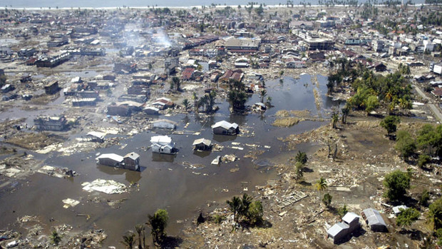
In this Jan. 2, 2005 file photo, a wide area of destruction is shown from an aerial view taken over Meulaboh, 250 kilometers (156 Miles) west of Banda Aceh, Indonesia. Researchers in the United States are hoping to use GPS data to speed up current warnings. (AP Photo/Dita Alangkara, File)

U.S. seismologists currently testing new warning system

by Andrew Pinsent - CBC News - May 5, 2012

Scientists in the United States have been testing an advanced tsunami warning system using GPS data, combined with traditional seismology networks, to attempt to detect the magnitude of an earthquake faster so warnings of potential tsunamis can get out to potentially affected areas sooner.

The prototype is called California Integrated Seismic Network (CISN), and is a collaboration between the United States Geological Survey (USGS) and The Gordon and Betty Moore Foundation, whose focus is on environmental conservation.

Country / Region Tags: 
Problem, Solution, SitRep, or ?: 

iPavement Puts a World of Knowledge Beneath Your Feet

submitted by Albert Gomez

good.is - May 3, 2012

Now that the United Nations has declared internet access a human right, any small step that helps get more people online is worth celebrating. That's why iPavement, the latest creation from Spanish tech company Via Inteligente, is so genius.

Constructed of a calcium carbonate stone, iPavement looks like your average piece of square tile. But one should never judge a tile by its cover. At iPavement's core is a 5GB microprocessor that can support both Bluetooth and Wi-Fi. Each tile will also come with its own suite of apps, offering users features like coupons to local businesses and maps to nearby places of interest. Via Inteligente's ultimate goal is to make cities more accessible and interesting by linking iPavement squares to people's increasing number of handheld devices.

(READ COMPLETE ARTICLE)

http://www.ipavement.com/en/index_eng.html

Country / Region Tags: 
Problem, Solution, SitRep, or ?: 

Pages

Subscribe to Visualization
howdy folks