You are here

Maps - Global

Primary tabs

This working group is focused on discussions about maps.

The mission of this working group is to focus on discussions about maps.

Members

Hank Rappaport Kathy Gilbeaux mdmcdonald typackett

Email address for group

maps-global@m.resiliencesystem.org

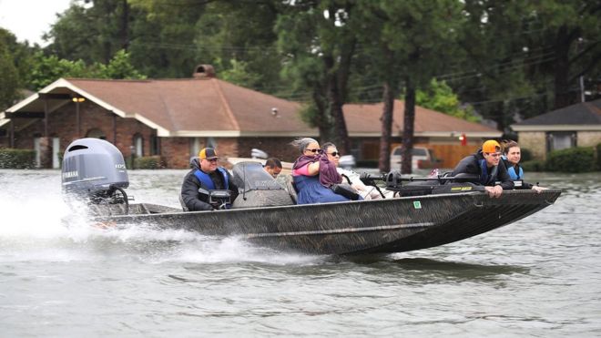
US Flood Risk 'Severely Underestimated'


During Hurricane Harvey, Port Arthur in Texas experienced some the most extreme impacts of flooding - Getty Images

Scientists and engineers have teamed up across the Atlantic to "redraw" the flood map of the US.

bbc.com - by Victoria Gill - 11 December 2017

Their work reveals 40 million Americans are at risk of having their homes flooded - more than three times as many people as federal flood maps show.

The UK-US team say they have filled in "vast amounts of missing information" in the way flood risk is currently measured in the country.

They presented the work at the 2017 American Geophysical Union meeting.

(CLICK HERE - READ COMPLETE ARTICLE)

CLICK HERE - 2017 American Geophysical Union meeting


Country / Region Tags: 
Problem, Solution, SitRep, or ?: 

NASA Map of Earth's Seasons Over 20 Years Highlights Climate Change

The visualization shows spring coming earlier and the Arctic ice caps receding over time

NASA - theguardian.com - AP - November 17, 2017

Nasa has captured 20 years of changing seasons in a striking new global map of planet Earth​.

The data visualization, released this week, shows Earth’s fluctuations as seen from space.

(READ COMPLETE ARTICLE)

CLICK HERE - NASA - The Living Planet - The Changing Colors of our Living Planet

CLICK HERE - NASA - Our Living Planet from Space

Country / Region Tags: 
Problem, Solution, SitRep, or ?: 

Facebook Disaster Maps - Using Data to Help Communities Recover and Rebuild

newsroom.fb.com - By Molly Jackman - June 7, 2017

Today, we are introducing disaster maps that use aggregated, de-identified Facebook data to help organizations address the critical gap in information they often face when responding to natural disasters. Many of these organizations worked with us to identify what data would be most helpful and how it could be put to action in the moments following a disaster.

This initiative is the product of close work with UNICEF, the International Federation of the Red Cross and Red Crescent Societies, the World Food Programme, and other organizations. 

(READ COMPLETE ARTICLE)

ALSO SEE RELATED ARTICLE HERE - Surveillance for good? Facebook tracks disaster victims

CLICK HERE - Mark Zuckerberg - Facebook

Country / Region Tags: 
Problem, Solution, SitRep, or ?: 

Map Shows How Paris Reversal Isolates U.S. From World


1Nicaragua refused to join the Paris Agreement because the country believes that the accord’s voluntary goals are insufficient.

2A brutal civil war and international sanctions made it difficult for Syria to attend the Paris negotiations and deliver an emissions-reduction goal.

Country / Region Tags: 
General Topic Tags: 
Problem, Solution, SitRep, or ?: 

How Likely Are You To Deal With A Zika Outbreak? Check This Map

huffingtonpost.com - August 15th 2016 - Anna Almendrala

Now that Zika virus is spreading locally in Florida, U.S. residents, and especially pregnant women, are growing alarmed at the risk that they may face in their own communities. 

A new map estimating the risk of local Zika spread around the globe shows a relatively small likelihood that most of North America and Northern Asia will be affected. By contrast, all the variables are in place for local spread in most of Africa, South and Southeast Asia. 

(VIEW COMPLETE ARTICLE)

Country / Region Tags: 
Problem, Solution, SitRep, or ?: 

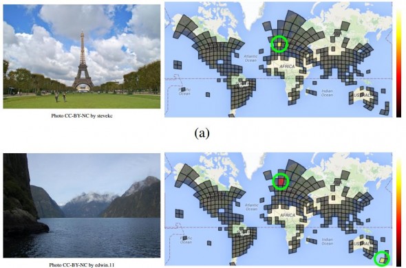
Google Unveils Neural Network with “Superhuman” Ability to Determine the Location of Almost Any Image


Guessing the location of a randomly chosen Street View image is hard, even for well-traveled humans. But Google’s latest artificial-intelligence machine manages it with relative ease.

CLICK HERE - PlaNet - Photo Geolocation with Convolutional Neural Networks

CLICK HERE - GeoGuessr

technologyreview.com - by Emerging Technology from the arXiv - February 24, 2016

Here’s a tricky task. Pick a photograph from the Web at random. Now try to work out where it was taken using only the image itself. . . .

. . . Tobias Weyand, a computer vision specialist at Google, and a couple of pals . . . have trained a deep-learning machine to work out the location of almost any photo using only the pixels it contains.

Their new machine significantly outperforms humans and can even use a clever trick to determine the location of indoor images and pictures of specific things such as pets, food, and so on that have no location cues.

(READ COMPLETE ARTICLE)


Country / Region Tags: 
General Topic Tags: 
Problem, Solution, SitRep, or ?: 

Zika - List of Map Resources

An expanding list of map resources related to Zika virus . . .

Map - PAHO | WHO - Zika
http://ais.paho.org/phip/viz/ed_zika_countrymap.asp

HealthMap - 2016 Zika Outbreak
http://www.healthmap.org/zika/#timeline

CDC - All Countries and Territories with Active Zika Virus Transmission
http://www.cdc.gov/zika/geo/active-countries.html

FRONTLINE - The Spread of Zika
http://apps.frontline.org/zika/

2016 Zika Linked Microcephaly / Fetal Brain Disruption Sequence
https://www.google.com/maps/d/viewer?mid=1RcVTrkYW6hax_iITjKUkEcBCVeI

Zika Virus - Zika Virus in United States, Territories, and Canada
https://www.google.com/maps/d/embed?mid=zv94AJqgUct4.kT4qLMXp3SLU&hl=en
OR
https://www.google.com/maps/d/viewer?hl=en&hl=en&authuser=0&authuser=0&mid=zv94AJqgUct4.kT4qLMXp3SLU

Zika Virus - Mexico
https://www.google.com/maps/d/viewer?mid=z-BJanWB3osk.kZw-wZDiyK14&hl=en_US 


Country / Region Tags: 
General Topic Tags: 
Problem, Solution, SitRep, or ?: 

Map - PAHO | WHO - Zika

Geographic distribution of confirmed cases of Zika virus
(locally acquired) in countries and territories of the Americas, 2015-2016

http://ais.paho.org/phip/viz/ed_zika_countrymap.asp

Country / Region Tags: 
General Topic Tags: 
Problem, Solution, SitRep, or ?: 

A Force for Good: How Digital Jedis are Responding to the Nepal Earthquake (Updated)

A building and statue damaged by the April 25th quake.

Image: A building and statue damaged by the April 25th quake.

irevolution.net - April 27th 2015

Digital Humanitarians are responding in full force to the devastating earthquake that struck Nepal. Information sharing and coordination is taking place online via CrisisMappers and on multiple dedicated Skype chats. The Standby Task Force (SBTF), Humanitarian OpenStreetMap (HOT) and others from the Digital Humanitarian Network (DHN) have also deployed in response to the tragedy.

(VIEW COMPLETE ARTICLE)

Country / Region Tags: 
General Topic Tags: 
Problem, Solution, SitRep, or ?: 

Crowdsourced Mapping Could Help Prevent the Next Big Ebola Outbreak

TAKEPART.COM by Jessica Dollin                                                                     April 14, 2015

Ebola dominated headlines this past year, but the epicenter of the outbreak wasn’t on a map until after the virus had infected and killed thousands. Without geographical resources, aid workers were tasked with the challenge of navigating remote areas to locate people in need of assistance.

Problem, Solution, SitRep, or ?: 

Pages

howdy folks