User login
Language
Anonymous's groups in this site
User is not a member of any group.
Your groups across all your sites
User is not a member of any group.
Recent Content
Who's online
There is currently 1 user online.
- mike kraft
You are here
New Field Guide Explores Open Data Innovations in Disaster Risk and Resilience
Primary tabs
Mon, 2014-03-31 21:16 — Kathy Gilbeaux
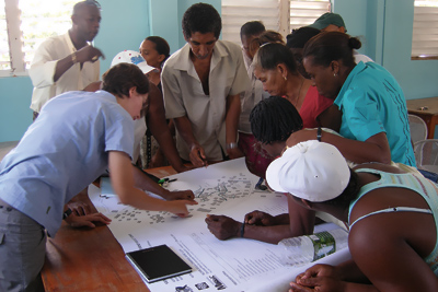
Citizen mapping can help pinpoint damage and locate risks, such as hillside instability that could threaten communities. GFDRR
worldbank.org - March 19, 2014
- The new World Bank Group field guide provides practical guidance for governments and organizations as they build their own open data programs for addressing disaster risk and resilience.
- It shows how participatory mapping projects can fill in government data gaps and keep existing data relevant as cities rapidly expand.
- Among the guide’s success stories are projects that quickly mapped disaster damage in the Philippines after Typhoon Yolanda and helped improve urban planning in Kathmandu.
CLICK HERE - Open Data for Resilience Initiative: Field Guide (134 page .PDF file)
Country / Region Tags:
General Topic Tags:
Problem, Solution, SitRep, or ?:
Groups this Group Post belongs to:


Recent Comments