You are here

Scientific Visualization

Primary tabs

The mission of this working group is to display and discuss the most important efforts to engage scientific visualization on issues of health and resilience.

General Topic Tags: 
Problem, Solution, SitRep, or ?: 
Group description: 
This Working Group is focused on scientific visualization pertinent to resilience and sustainability.
Group roles and permissions: 
Use default roles and permissions
Group visibility: 
Public - accessible to all site users

Members

admin Albert Gomez bart.stidham ChrisAllen DeannaPolk efrost
rwelborn

Email address for group

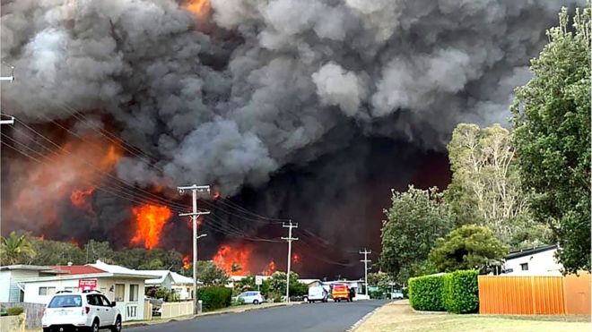
Australia Bushfires: State of Emergency Declared Over 'Catastrophic' Threat


Thousands of people have been driven from their homes - AFP

Two Australian states have declared a state of emergency as bushfires bring a "catastrophic" threat to heavily populated areas of the nation's east.

bbc.com - 11 November 2019

At least three people are dead and thousands have been displaced by three days of dangerous weather conditions in New South Wales (NSW) and Queensland.

But officials say the worst danger will come on Tuesday for areas around Sydney, the nation's largest city.

More than 120 bushfires are burning across the two states.

(CLICK HERE - READ COMPLETE ARTICLE)

ALSO SEE RELATED INFORMATION WITHIN THE LINKS BELOW . . .

CLICK HERE - Wildfires Rage In Australian State: 'We've Simply Never Had This Number Of Fires'

Country / Region Tags: 
Problem, Solution, SitRep, or ?: 

US Flood Risk 'Severely Underestimated'


During Hurricane Harvey, Port Arthur in Texas experienced some the most extreme impacts of flooding - Getty Images

Scientists and engineers have teamed up across the Atlantic to "redraw" the flood map of the US.

bbc.com - by Victoria Gill - 11 December 2017

Their work reveals 40 million Americans are at risk of having their homes flooded - more than three times as many people as federal flood maps show.

The UK-US team say they have filled in "vast amounts of missing information" in the way flood risk is currently measured in the country.

They presented the work at the 2017 American Geophysical Union meeting.

(CLICK HERE - READ COMPLETE ARTICLE)

CLICK HERE - 2017 American Geophysical Union meeting


Country / Region Tags: 
Problem, Solution, SitRep, or ?: 

UN Centre Improving Lives by Linking People and Humanitarian Data


Humanitarian aid workers help fight cholera in the Democratic Republic of the Congo. Photo: OCHA/J-L. Mbalivoto

unmultimedia.org - 22 December 2017

Access to data is crucial for humanitarians responding to various crises worldwide.

For example, aid workers feeding hungry people in Nigeria use a mobile-based platform to monitor the price of rice and other staples to know when costs increase.

To better assist these professionals, the UN has opened a global humanitarian data centre in the Netherlands that aims to improve lives by connecting people and data.

Veronique Durroux spoke to Javier Terán Castro, a statistician with the UN humanitarian affairs office, OCHA, who explained how it functions.

http://www.unmultimedia.org/radio/english/2017/12/un-centre-aims-to-connect-people-and-humanitarian-data-to-improve-lives/#.Wj0Cma3MzFR

The Centre for Humanitarian Data - https://centre.humdata.org

HDX - https://data.humdata.org

Country / Region Tags: 
Problem, Solution, SitRep, or ?: 

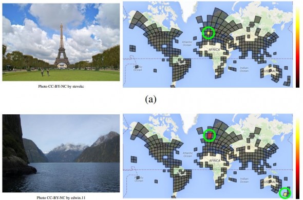
Google Unveils Neural Network with “Superhuman” Ability to Determine the Location of Almost Any Image


Guessing the location of a randomly chosen Street View image is hard, even for well-traveled humans. But Google’s latest artificial-intelligence machine manages it with relative ease.

CLICK HERE - PlaNet - Photo Geolocation with Convolutional Neural Networks

CLICK HERE - GeoGuessr

technologyreview.com - by Emerging Technology from the arXiv - February 24, 2016

Here’s a tricky task. Pick a photograph from the Web at random. Now try to work out where it was taken using only the image itself. . . .

. . . Tobias Weyand, a computer vision specialist at Google, and a couple of pals . . . have trained a deep-learning machine to work out the location of almost any photo using only the pixels it contains.

Their new machine significantly outperforms humans and can even use a clever trick to determine the location of indoor images and pictures of specific things such as pets, food, and so on that have no location cues.

(READ COMPLETE ARTICLE)


Country / Region Tags: 
General Topic Tags: 
Problem, Solution, SitRep, or ?: 

Humanity from Space

pbs.org - July 21, 2015

From the global perspective of space, this 2-hour special reveals the breathtaking extent of our influence, revealing how we’ve transformed our planet and produced an interconnected world of extraordinary complexity.

A journey through 12,000 years, Humanity from Space shows how seemingly small flashes of innovation have changed the course of civilization; innovations that touch all of us today in ways unimaginable to our ancestors. And we’ll gaze into the future at the new challenges we’ll face in order to survive as our global population soars because of our success.

CLICK HERE - PBS - Humanity from Space

CLICK HERE - YouTube - Humanity from Space

Country / Region Tags: 
Problem, Solution, SitRep, or ?: 

How Computer Modelers Took On the Ebola Outbreak

submitted by Sarah Slaughter         


At The Epidemic’s Epicenter: A Liberian child sits in an Ebola isolation ward housing people who might have contracted the contagious disease.  Photo: John Moore/Getty Images

Did real-time epidemic modeling save lives in West Africa?

spectrum.ieee.org - by David Brown - May 28, 2015

. . . “agent-based” models will give a more nuanced picture of how pathogens affect and sicken a population. “This is the wave of the future,” says Stephen Eubank, deputy director of the Virginia Tech lab. “It’s going to take a concerted effort to gather the data and the expertise. But it’s going to happen.”

And so, too, will another Ebola outbreak.

(READ COMPLETE ARTICLE)

Problem, Solution, SitRep, or ?: 

United Nations General Assembly Adopts Resolution on Global Geospatial Information Management


un.org - February 26, 2015

Delegates in the General Assembly of the United Nations adopted a consensus resolution last week, by which they addressed global geospatial information management. The document entitled “A global geodetic reference frame for sustainable development” (A/RES/69/266) urges States to voluntarily implement open sharing of geodetic data, standards and conventions, inviting them to improve national geodetic infrastructure and engage in multilateral cooperation that addressed infrastructure gaps and duplications, towards the development of a more sustainable geodetic reference frame.

(READ COMPLETE ARTICLE)

(ALSO SEE RELATED INFORMATION HERE)

Country / Region Tags: 
General Topic Tags: 
Problem, Solution, SitRep, or ?: 

NASA: Earth JUST Dodged Comms-Killing SOLAR BLAST in 2012

The Doomsday scenario we should have been worrying about

theregister.co.uk - by Iain Thomson - March 19, 2014

Video - A new analysis of data from NASA's Solar TErrestrial RElations Observatory (STEREO) by Chinese and Berkeley helioboffins shows that a July 2012 solar storm of unprecedented size would have wiped out global electronic systems if it had occurred just nine days earlier.

"Had it hit Earth, it probably would have been like the big one in 1859, but the effect today, with our modern technologies, would have been tremendous," said UC Berkeley research physicist Janet Luhmann.

The 1859 storm, also known as the Carrington Event, after the British astronomer who recorded it, swept over the Earth at the end of August and is the largest recorded solar storm in history.

Country / Region Tags: 
Problem, Solution, SitRep, or ?: 

Pages

howdy folks
Page loaded in 0.724 seconds.