You are here

Scientific Visualization

Primary tabs

The mission of this working group is to display and discuss the most important efforts to engage scientific visualization on issues of health and resilience.

General Topic Tags: 
Problem, Solution, SitRep, or ?: 
Group description: 
This Working Group is focused on scientific visualization pertinent to resilience and sustainability.
Group roles and permissions: 
Use default roles and permissions
Group visibility: 
Public - accessible to all site users

Members

admin Albert Gomez bart.stidham ChrisAllen DeannaPolk efrost
rwelborn

Email address for group

Crisis maps

voices.mckinseyonsociety.com - Patrick Meier

Crisis-mapping technology has emerged in the past five years as a tool to help humanitarian organizations deliver assistance to victims of civil conflicts and natural disasters. Crisis-mapping platforms display eyewitness reports submitted via e-mail, text message, and social media. The reports are then plotted on interactive maps, creating a geospatial record of events in real time.

(VIEW COMPLETE ARTICLE)

Country / Region Tags: 
General Topic Tags: 
Problem, Solution, SitRep, or ?: 

UN - World Food Programme - Hunger Map

                                           (TO ENLARGE MAP - CLICK ON MAP IMAGE BELOW)


The map shows the prevalence of undernourishment in the total population as of 2010 - 2012. The indicator is an estimate of the percentage of the population having access to an amount of energy from food insufficient to maintain a healthy life.

http://www.wfp.org/hunger/downloadmap

Country / Region Tags: 
Problem, Solution, SitRep, or ?: 

Verily: Crowdsourced Verification for Disaster Response


irevolution.net - by Patrick Meier - February 19, 2013

Social media is increasingly used for communicating during crises. This rise in Big (Crisis) Data means that finding the proverbial needle in the growing haystack of information is becoming a major challenge.

QCRI and Masdar have launched an experimental  platform called Verily. We are applying best practices in time-critical crowd-sourcing coupled with gamification and reputation mechanisms to leverage the good will of (hopefully) thousands of digital Samaritans during disasters.

(READ COMPLETE ARTICLE)

Veri.ly
http://www.veri.ly/

Country / Region Tags: 
Problem, Solution, SitRep, or ?: 

This Is Now

submitted by Albert Gomez

now.jit.su

This is Now project is a visual composition which uses real-time updates from the ever popular Instagram application based on users geo-tag locations. The tool streams photos instantly as soon as they are uploaded on Instagram and captures a city's movement, in a fluid story.

http://now.jit.su/

Country / Region Tags: 
Problem, Solution, SitRep, or ?: 

Improve Tsunami Warnings by Placing GPS on Commercial Ships

While in transit from Hawaii to Guam, the research vessel Kilo Moana detected the February 2010 Chilean tsunami. Credit: University of Hawaii, SOEST

submitted by Samuel Bendett

Homeland Security News Wire - May 8, 2012

Researchers find that commercial ships travel across most of the globe and could provide better warnings for potentially deadly tsunamis; this finding came as a surprise because tsunamis have such small amplitudes in the deep water, in contrast to their size when they reach the coastline, that it seemed unlikely that the tsunami would be detected using GPS unless the ship was very close to the source and the tsunami was very big

Commercial ships travel across most of the globe and could provide better warnings for potentially deadly tsunamis, according to a study published by scientists at the University of Hawaii – Manoa (UHM) and the National Oceanic and Atmospheric Administration’s Pacific Tsunami Warning Center.

Country / Region Tags: 
Problem, Solution, SitRep, or ?: 

Researchers Use GPS Data to Speed Up Tsunami Warnings


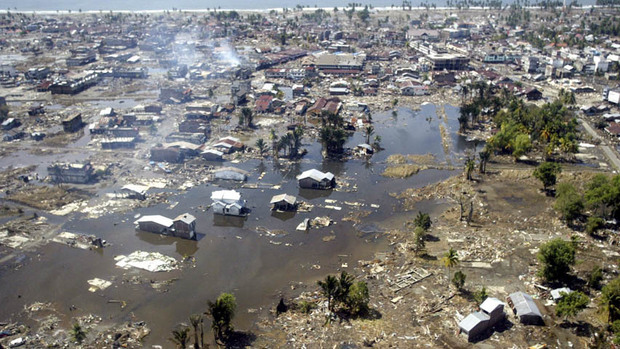
In this Jan. 2, 2005 file photo, a wide area of destruction is shown from an aerial view taken over Meulaboh, 250 kilometers (156 Miles) west of Banda Aceh, Indonesia. Researchers in the United States are hoping to use GPS data to speed up current warnings. (AP Photo/Dita Alangkara, File)

U.S. seismologists currently testing new warning system

by Andrew Pinsent - CBC News - May 5, 2012

Scientists in the United States have been testing an advanced tsunami warning system using GPS data, combined with traditional seismology networks, to attempt to detect the magnitude of an earthquake faster so warnings of potential tsunamis can get out to potentially affected areas sooner.

The prototype is called California Integrated Seismic Network (CISN), and is a collaboration between the United States Geological Survey (USGS) and The Gordon and Betty Moore Foundation, whose focus is on environmental conservation.

Country / Region Tags: 
Problem, Solution, SitRep, or ?: 

Future Trends in Geospatial Information Management: The Five to Ten Year Vision

submitted by Samuel Bendett

United Nations Initiative on Global Geospatial Information Management - April 24, 2012

A working group was established to assess the future trends in geospatial information management at the 1st meeting of the UN Committee on GGIM in Seoul, Korea. Chaired by Dr. Vanessa Lawrence, Director General and Chief Executive of Ordnance Survey, the working group has received written inputs from 29 persons or institutions. A summary of the future trends shall be presented during this forum in Amsterdam, followed by discussion among all the participants. Meanwhile, the process of soliciting views on future trends continue and the working group welcomes any additional inputs. A consolidated paper on the future trends shall be discussed in the 2nd Session of the Committee of Experts on Global Geospatial Information Management.

http://ggim.un.org/

Background paper:
Future trends in geospatial information management: the five to ten year vision (8 page .PDF file)


Country / Region Tags: 
General Topic Tags: 
Problem, Solution, SitRep, or ?: 

Looking Back on the Limits of Growth


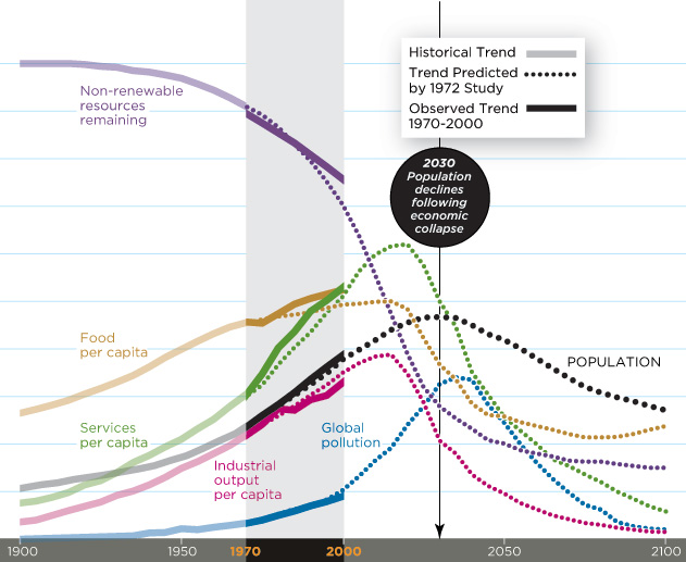
Chart Sources: Meadows, D.H., Meadows, D.L., Randers, J. and Behrens III, W.W. (1972) /  Linda Eckstein

by Mark Strauss - Smithsonian Magazine - April 2012

Recent research supports the conclusions of a controversial environmental study released 40 years ago: The world is on track for disaster. So says Australian physicist Graham Turner, who revisited perhaps the most groundbreaking academic work of the 1970s,The Limits to Growth.

Written by MIT researchers for an international think tank, the Club of Rome, the study used computers to model several possible future scenarios. The business-as-usual scenario estimated that if human beings continued to consume more than nature was capable of providing, global economic collapse and precipitous population decline could occur by 2030.

(GO TO THE SMITHSONIAN MAGAZINE ARTICLE)

Limits to Growth: The 30-Year Update

The Club of Rome

Country / Region Tags: 
Problem, Solution, SitRep, or ?: 

Transforming Earthquake Detection?

submitted by Linton Wells

sciencemag.org - January 20, 2012

Earthquakes are a collective experience. Citizens have long participated in earthquake science through the reporting, collection, and analysis of individual experiences. The value of citizen-generated status reports was clear after the 1995 Kobe, Japan, earthquake (1). Today's communications infrastructure has taken citizen engagement to a new level: Earthquake-related Twitter messages can outrun the shaking (2), Internet traffic detects earthquakes (37) and maps the distribution of shaking in minutes (810), and accelerometers in consumer electronic devices record seismic waveforms (1116). What are we learning from this flood of data, and what are the limitations? How do we harness these new capabilities for scientific discovery, and what is the role of education?

(GO TO THE COMPLETE ARTICLE)

Country / Region Tags: 
General Topic Tags: 
Problem, Solution, SitRep, or ?: 

Pages

howdy folks
Page loaded in 0.746 seconds.