User login
Language
Anonymous's groups in this site
User is not a member of any group.
Your groups across all your sites
User is not a member of any group.
Recent Content
Who's online
There are currently 0 users online.
You are here
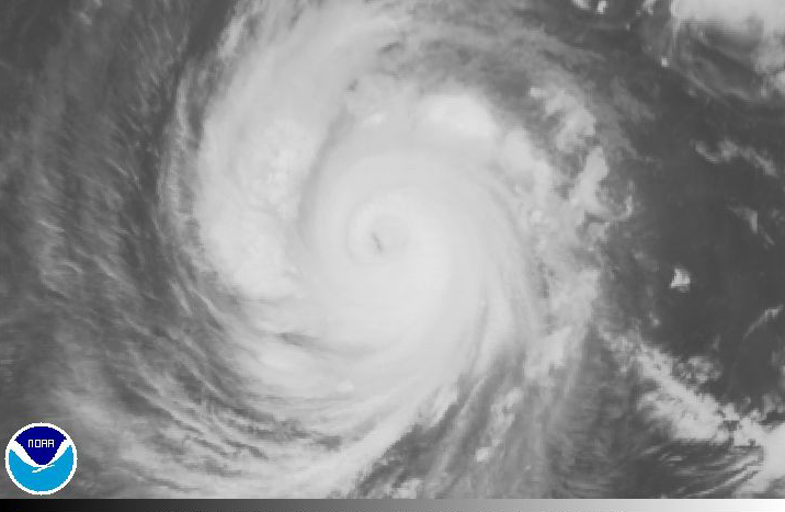
Typhoon Francisco on Course for Japan — May Follow Typhoon Wipha’s Path … Developed in a Similar Area (VIDEO)
Primary tabs
(CLICK ON IMAGE BELOW - NOAA - Francisco Long Floater - Infrared Channel 4 Imagery Loop)
enenews.com - Energy News - October 19, 2013
Weather Channel, Oct. 18, 2013 at 9:45p ET: Super Typhoon Francisco Brushes Guam, Could Threaten Japan Next Week [...] A tropical cyclone is dubbed a “super typhoon” when maximum sustained winds reach at least 150 mph – the equivalent of a Category 4 hurricane on the Saffir-Simpson scale. [...] Conditions appear favorable for development [... allowing] the typhoon to strengthen in intensity, possibly to 160 mph (Category 5 status) over the next few hours. After that, Francisco will move into a region of cooler ocean temperatures, which cause the typhoon to weaken. Francisco may threaten southern Japan early next week, however the current forecast from the Joint Typhoon Warning Center indicates that the typhoon will be much weaker by that point. That said, intensity forecasts at five days out in time can be highly uncertain [...]
Joint Typhoon Warning Center, Oct. 19, 2013: [...] as the system continues further to the north, a strong poleward outflow channel may develop which could help to offset the cooler sea SSTs and maintain higher intensities. [...] All objective aids, with the exception of GFDN, are beginning to indicate a recurve scenario, but widely vary in position and track speed of the system. [...]
(CLICK HERE FOR ADDITIONAL INFORMATION)
(CLICK HERE FOR MAP OF PROJECTED PATH)
CLICK HERE FOR ADDITIONAL INFORMATION FROM THE JOINT TYPHOON WARNING CENTER (JTWC)


Recent Comments