User login
Language
Anonymous's groups in this site
User is not a member of any group.
Your groups across all your sites
User is not a member of any group.
Recent Content
Who's online
There are currently 0 users online.
You are here
Map - Global Forest Watch Fires
Thu, 2019-08-22 09:00 — Kathy Gilbeauxfires.globalforestwatch.org
Global Forest Watch Fires (GFW Fires) is an online platform for monitoring and responding to forest and land fires using near real-time information. GFW Fires can empower people to better combat harmful fires before they burn out of control and hold accountable those who may have burned forests illegally.
GFW Fires combines real-time satellite data from NASA’s Active Fires system, high resolution satellite imagery, detailed maps of land cover and concessions for key commodities such as palm oil and wood pulp, weather conditions and air quality data to track fire activity and related impacts in the South East Asia region. GFW Fires also offers on-the-fly analysis to show where fires occur, and help understand who might be responsible.
By working with national and local governments, NGOs, corporations, and individuals, GFW Fires is working to quicken fire response time, ramp up enforcement against illegal fires, help ensure those who are illegally burning are held accountable, and coordinate relationships between government agencies.
(CLICK HERE - READ COMPLETE ARTICLE)
Facebook Disaster Maps - Using Data to Help Communities Recover and Rebuild
Thu, 2017-06-08 15:59 — Kathy Gilbeauxnewsroom.fb.com - By Molly Jackman - June 7, 2017
Today, we are introducing disaster maps that use aggregated, de-identified Facebook data to help organizations address the critical gap in information they often face when responding to natural disasters. Many of these organizations worked with us to identify what data would be most helpful and how it could be put to action in the moments following a disaster.
This initiative is the product of close work with UNICEF, the International Federation of the Red Cross and Red Crescent Societies, the World Food Programme, and other organizations.
ALSO SEE RELATED ARTICLE HERE - Surveillance for good? Facebook tracks disaster victims
Haiti - Hurricane Matthew - Cholera - Map Resources
Fri, 2016-10-28 09:43 — Kathy GilbeauxAn expanding list of map resources related to Hurricane Matthew and Cholera response in Haiti . . .
CLICK HERE - Haiti Data - haitidata.org
CLICK HERE - PAHO - WHO - Visualizations on the impact of Hurricane Matthew in Haiti
CLICK HERE - NASA - Landsat Image Gallery - Hurricane Matthew’s Aftermath in Haiti
CLICK HERE - MINUSTAH - Matthew Relief
Zika - List of Map Resources
Tue, 2016-02-16 10:50 — Kathy GilbeauxAn expanding list of map resources related to Zika virus . . .
Map - PAHO | WHO - Zika
http://ais.paho.org/phip/viz/ed_zika_countrymap.asp
HealthMap - 2016 Zika Outbreak
http://www.healthmap.org/zika/#timeline
CDC - All Countries and Territories with Active Zika Virus Transmission
http://www.cdc.gov/zika/geo/active-countries.html
FRONTLINE - The Spread of Zika
http://apps.frontline.org/zika/
2016 Zika Linked Microcephaly / Fetal Brain Disruption Sequence
https://www.google.com/maps/d/viewer?mid=1RcVTrkYW6hax_iITjKUkEcBCVeI
Zika Virus - Zika Virus in United States, Territories, and Canada
https://www.google.com/maps/d/embed?mid=zv94AJqgUct4.kT4qLMXp3SLU&hl=en
OR
https://www.google.com/maps/d/viewer?hl=en&hl=en&authuser=0&authuser=0&mid=zv94AJqgUct4.kT4qLMXp3SLU
Zika Virus - Mexico
https://www.google.com/maps/d/viewer?mid=z-BJanWB3osk.kZw-wZDiyK14&hl=en_US
Map - PAHO | WHO - Zika
Tue, 2016-02-16 10:31 — Kathy GilbeauxGeographic distribution of confirmed cases of Zika virus
(locally acquired) in countries and territories of the Americas, 2015-2016
World Health Organization (WHO) - Ebola Portal - Map
Sun, 2014-09-28 21:27 — Kathy Gilbeaux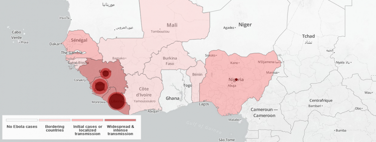
Ecological Footprint of Consumption Compared to Biocapacity
Sat, 2014-03-15 11:50 — Kathy Gilbeauxvia chartsbin.com
This map compares each country's total consumption Footprint with the biocapacity available within its own borders.
Many countries rely, in net terms, on the biocapacity of other nations to meet domestic demands for goods and services. For example: Japan imports Ecuadorian wood to make paper; Europe imports meat fed on Brazilian soy; the United States imports Peruvian cotton; and China obtains lumber from Tanzania.
- World Total Biocapacity: 1.78 gha per capita
- World Ecological Footprint of Consumption: 2.7 gha per capita (i.e. we are using more resources than the Earth can provide.)
Currently less than 20 percent of the world's population living in countries that can keep up with their own demands.
What is a global hectare (gha)?
A global hectare is a common unit that encompasses the average productivity of all the biologically productive land and sea area in the world in a given year. Biologically productive areas include cropland, forest and fishing grounds, and do not include deserts, glaciers and the open ocean.
Data source: Global Footprint Network's 2010 Edition.
Recent Comments